Driver Behaviour / Conflict Studies
Robust record to enable the most rigorous analysis of driver behaviour
Robust record to enable the most rigorous analysis of driver behaviour
Driver Behaviour / Conflict Studies

By marrying the capability to log and display data within a GIS environment to ‘traditional’ transport data capture, we are able to provide a much more robust record to enable the most rigorous analysis of driver behaviour.
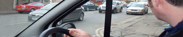
For example, we have utilised GIS to accurately digitise the location of driver incidents, captured from video data recorded on site. Incidents are presented geographically with a conflict video to illustrate the incident in question and provide the client with a short video of the incident recorded, by using GIS this allows us to run spatial queries and produce outputs relative to site or incident type.
This could equally be applied to traffic conflicts, pedestrian conflicts, or indeed any other type of incident which requires the ability to display information on occurrences of a single type. This approach can provide an immediate ‘of the shelf’ record for AIP teams and others saving many, many hours of investigation time.
Related Services

People and NMU MovementsUnderstanding these complex movements and behavioural patterns. Read More...


People and NMU MovementsUnderstanding these complex movements and behavioural patterns. Read More...